The USDA plant hardiness zone map is a great place to start when determining what plants are suitable for your garden. Although not perfect, it gives you a good idea of what plants may thrive and can also help you determine when to plant what. To explore your own zone, you can use the input box above to get an interactive zone map of the county where your zip code is located.
What are the plant hardiness zones?
In its essence, the USDA plant hardiness zones is a grouping based on the average annual minimum temperature. The zones are grouped by areas that are within 10 degrees Fahrenheit of each other, and then each zone is again sub-divide into two groups that are within 5 degrees Fahrenheit of each other. That is why you see for example zone 2a and 2b. All areas that are categorized as zone 2 are within 10 degrees of each other, while everything within each of the two subzones are within 5 degrees of each other.
There are 13 main zones (1 through 13), and each has two subzones, so in total there are 26 different planting zones.
If you look at the chart I have composed below, you can clearly see that there is a linear relationship between the zones. Zone 1a starts on the left side of the x-axis and then it goes all the way to zone 13b. This linear relationship can be a bit disguised when you look at a table representation of the data.
How can you use the plant hardiness zones?
If you live in an area like San Diego, which ranges from around zone 8 to zone 10, you can expect an average minimum winter temperature of around 20-30 Fahrenheit. On the other hand, if you live in Wisconsin, which ranges around zone 3-5, you would have an average minimum temperature of around -40 to -20 Fahrenheit.
As you can tell, the minimum temperature in San Diego and Wisconsin are vastly different. Since the temperatures are so different, it also impacts what kinds of plants will thrive there, which is one thing that you can use the zones for. You likely know if it gets cold or not where you live, but knowing the zone can help you determine what plants will survive there or not.
Another difference between San Diego and Wisconsin is when it starts to get hot enough for certain plants to grow. This is how you can use the planting zone to determine when to plant what. If you look at a seed package of tomatoes for example, they often have when you should plant the seeds based on what zone you are in.
Here is the back of some tomato seeds to give you an example
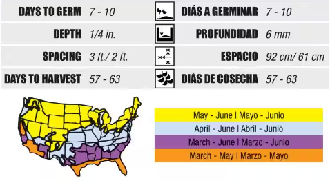
Although the image above does not specifically say the zone name (it should), you can tell that in the warmer places you can start planting earlier.
So what you can do is to enter your zip code in the box at the top of this page and it will tell you the zone that you reside in. You can then use that information when you look for plants at your local garden center, or when looking online.
What are some limitations of the plant hardiness zones?
One flaw of the zones is that there is a lot of variation locally. Your garden may be a lot warmer than what is reported and you may have more sun than the average place. What makes a plant happy is not solely determined by the average minimum temperature, which is what information the hardiness zone gives you.
Another thing about the zones is that they are more helpful when you are doing planning outside of going to any of your local garden centers. More likely than not, the plants that they sell there are going to be suitable for your environment, which makes the point of looking up your zone a little more mute. Nevertheless, being aware of what zone you are in can be helpful when determining when to start planting various plants.
In addition to knowing the hardiness zone that you live in, you can also use our free garden planner software to plan your perfect garden.